-
Earth Science Journal
Plate Tectonics
Take informal notes on the following information.
Be sure to write down the information in your own words.
What Wegener did not know
Alfred Wegener did not correctly explain how Continents “DRIFTED” worldwide, so his theory was ridiculed in the scientific community. At the time, we did not have the technology to explore the depths of the ocean floor.
Tectonic patterns are also found on land and sea!
Felsic Volcanoes are found in long mountain chains that wrap their way around the edges of continents and oceans.
They also form long island arcs.
(i.e., Aleutian Island arc)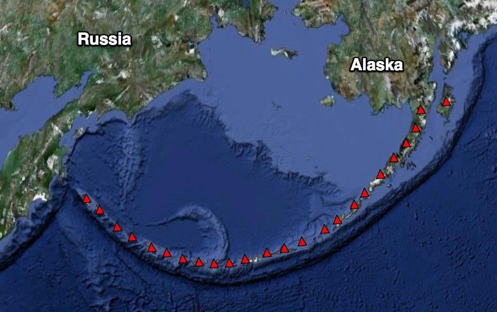
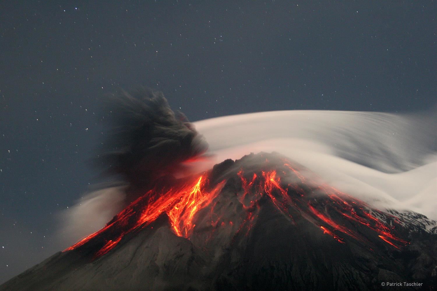
These volcanoes are very violent and steep and form Stratovolcanoes.
 Felsic Volcanoes are also known as Composite or Strato-volcanoes. They are furious and explode violently, sending ash into the air that settles on the sides of the volcano, then the lava comes out of the volcano covering the ash. This happens over and over, building up layers of lava and ash on the volcano's sides.
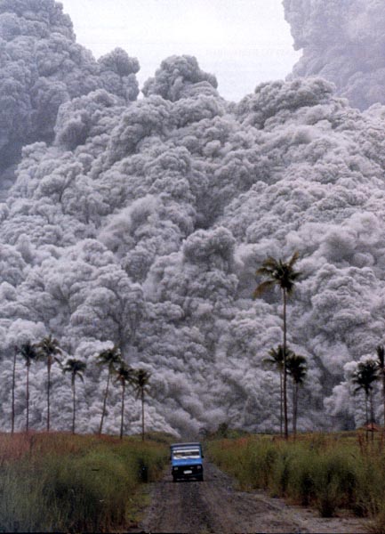
Felsic volcanoes can produce pyroclastic flows!What is a Pyroclastic Flow?A fast-moving current of extremely hot volcanic gas and pulverized rock travels down the side of a felsic volcano. With temperatures well over 1000 degrees Celsius and moving speeds over 100 miles an hour, it will kill everything in its path.Mount Vesuvius, Italy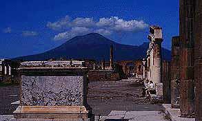 Vesuvius79 A.D. eruption and pyroclastic flowsBuried two Roman Cities
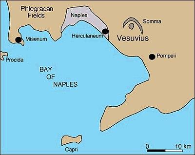
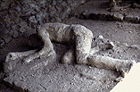
A Pyroclastic Flow similar to this buried the city of Pompeii!
People were sealed in tombs with volcanic ash.
Composition of the Crust
Composition of Continental Crust – made mostly of the plutonic, felsic, igneous rock granite. Density = 2.7 g/cm3
Composition of Oceanic Crust – made mostly of the volcanic, mafic, igneous rock basalt. Density = 3.0 g/cm3
Think: Salty oceans with a basalty bottom.
Can you find this on your reference tables?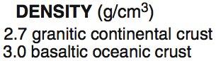 Circle this important bit of information in your reference tables.
So where are these dangerous volcanoes?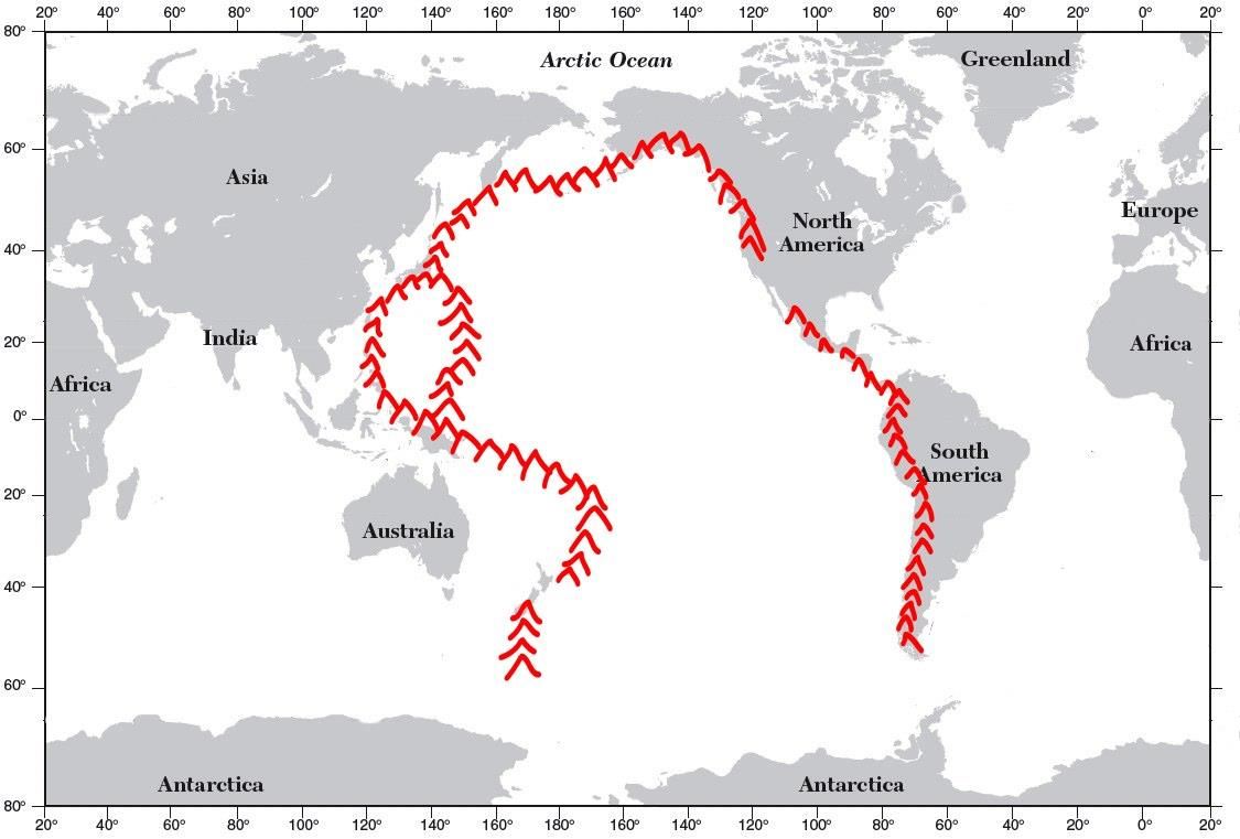 The "Ring of Fire" is a Felsic chain of violent volcanoes surrounding the Pacific Ocean.Where are the deepest parts of the ocean?
Deep Ocean TrenchesNear Continents and island arcs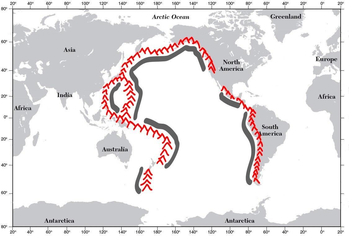 The deepest parts of the ocean are found close to the continents near these felsic volcano chains.
Find and label the Mariana Trench.The Mariana Trench is the deepest part of the ocean.To better illustrate the actual depth of the Mariana Trench, consider the following: if Mount Everest, which is the tallest point on earth at 8,850 meters (29,035 feet), were set in the Mariana Trench, there would still be 2,183 meters (7,166 feet) of water left above it.How many feet are there in a mile anyway?
Meanwhile, strange things appeared in the HAWAIIAN Islands' volcanic rocks.
Paleomagnetism: Ancient magnetics of the earth
It so happens that when lava solidifies, it captures the earth’s magnetic field when the rocks cool. People studying these lava flows started noticing an interesting pattern. At first, they tossed the results out as just instrument failure until the pattern kept repeating itself over and over again on all the different Hawaiian Islands. Basalt from some lava flows would point north in the direction that compasses point in today, while lava-cooled basalt layers that were deeper underground pointed north in the opposite direction (South Today). This was a great mystery at the time.

Using the key, color the layers of basalt as you dig into the earth and go back deeper in time.
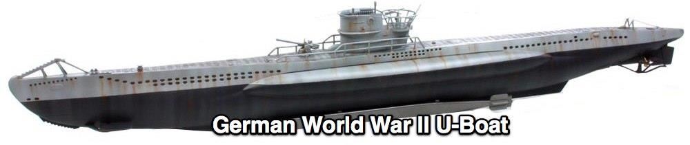
It took a war to help figure out these mysteries. During World War II, German U-BOAT submarines caused havoc to the American and British Navy. In order to find these elusive submarines, a clear map and an understanding of the ocean floor were necessary. The U.S. Navy crisscrossed the Atlantic Ocean, dragging behind them magnetometers (something like a compass) that mapped the magnetic field of the ocean floor as they looked for these German submarines. They discovered that interesting patterns had emerged on the ocean floor.
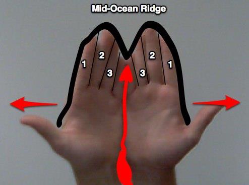
Mafic Volcanoes and Mid-Ocean Ridges – The longest mountain chain in the world is hidden from our sight because it is at the bottom of the middle of all the oceans in the world!This mid-ocean ridge is a mountain range of mafic volcanoes.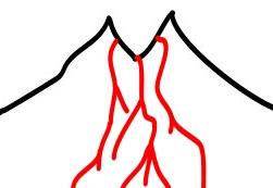 Think: Mafic in the Middle formed from deep Mantle Magma.
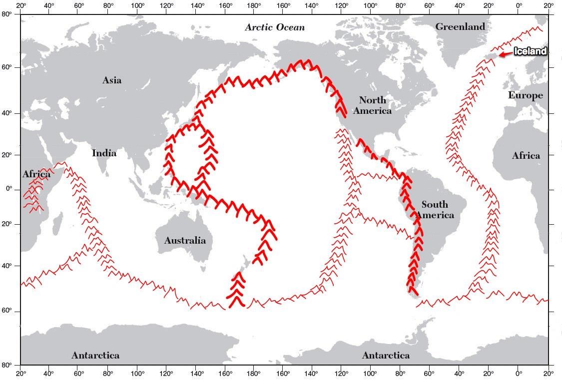
The mid-ocean ridge system has been compared to a wound in the earth that never heals.
They look like stitches in a baseball.
These Mafic Mountains show divergent plate boundaries.
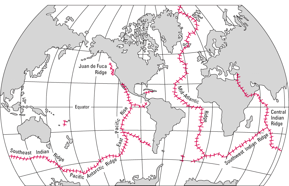
The Earth is being ripped apart at these ridge systems, and deep mafic magma is rising to create a new ocean floor.
Rising an average of about 4,500 meters (m) above the seafloor, the mid-ocean ridge is higher than all the mountains in the United States except for Mount McKinley in Alaska (6,194 m). Though hidden beneath the ocean surface, the global mid-ocean ridge system is the biggest topographic feature on the surface of our planet.
Life on the Ridges – Strange life has recently been discovered along with these mid-ocean ridge systems. In places where sunlight does not shine, large communities of animals thrive. What allows these animals to survive in conditions that would seem so hostile?
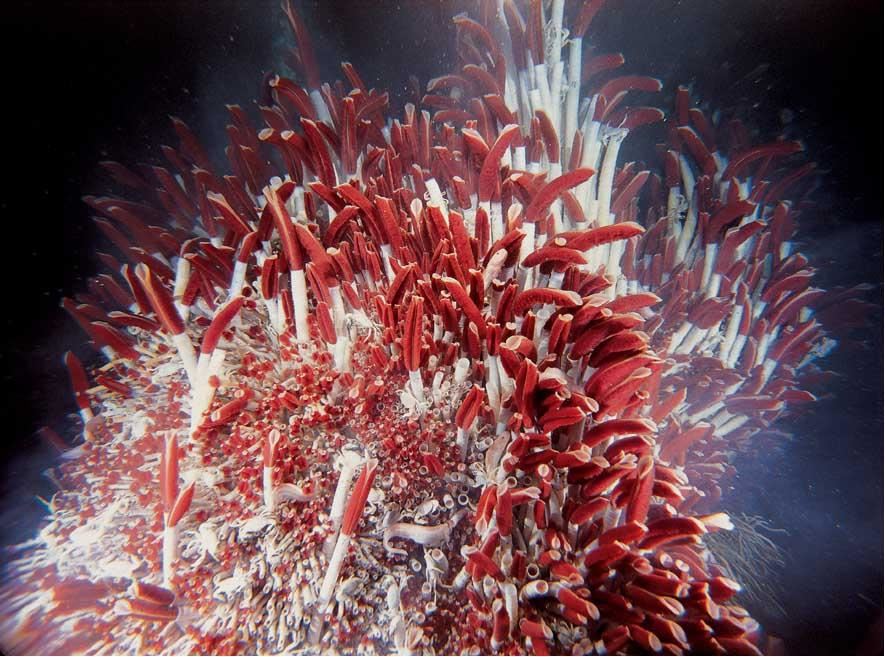
Bacteria feed off this energy coming from the earth.
They chemically synthesize food using heat energy from the earth.This process is called
Chemosynthesis!Other animals feed on the bacteria.
One of the very few food chains that does not get its energy from the sun.
Hot hydrothermal vents give energy to this strange deep ocean life.
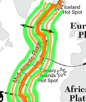
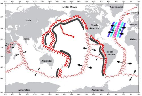
The magnetism of the Mid-ocean Ridge
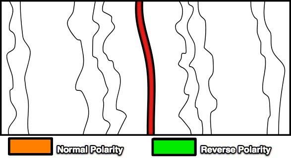
Color the magnetic stripes on one side of the ridge using your key.
Mid-ocean Ridge
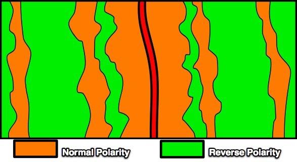
Now figure out what the other side will look like and color.

Take out your reference tables and draw some magnetic stripes along the ridges using the same color scheme.
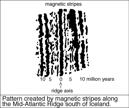
Scientists also checked the age of the ocean crustal rocks and found that the youngest rocks were at these mid-ocean ridges, and the rocks get older as you travel away from the ridge.
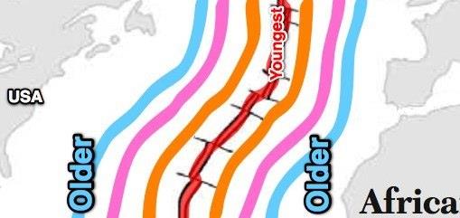
What does this suggest?
New ocean crust is being formed at mid-ocean ridges and spreading out from this center.
Three things have to happen to achieve this pattern.
1. Lava must be coming up at the ridge, capturing the Earth's magnetic field.
2. The tectonic plates must move apart at the ridges.
3. The magnetic field of the Earth must reverse its polarity.This proves that the seafloor is spreading in the Mid-ocean Ridges!
Sea Floor Spreading in a nutshell
When igneous rocks cool they trap the earth's magnetic field.
The earth's magnetic poles have reversed many times in the past.
This reversal is captured and shown as magnetic striping along mid-ocean ridges.Conclusive Evidence: The seafloor is being created and is spreading apart at the mid-ocean ridges.
Mid Ocean Ridges!
A handy way to remember
Normal Faults along the ridge
Making Magnetic Strips!
Do NowGet a red and blue crayonGet a large piece of white paper.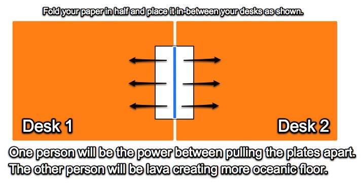 Hot Spot Volcanoes – Sometimes volcanoes are not located along volcanic chains. Volcanoes that are unique and separate from the mafic ridge systems or the felsic mountain systems are located over “Hot Spots” in the earth’s mantle. These hot spot volcanoes often produce large volcanic islands like Hawaii. This very fluid mafic lava most often produces shield volcanoes.
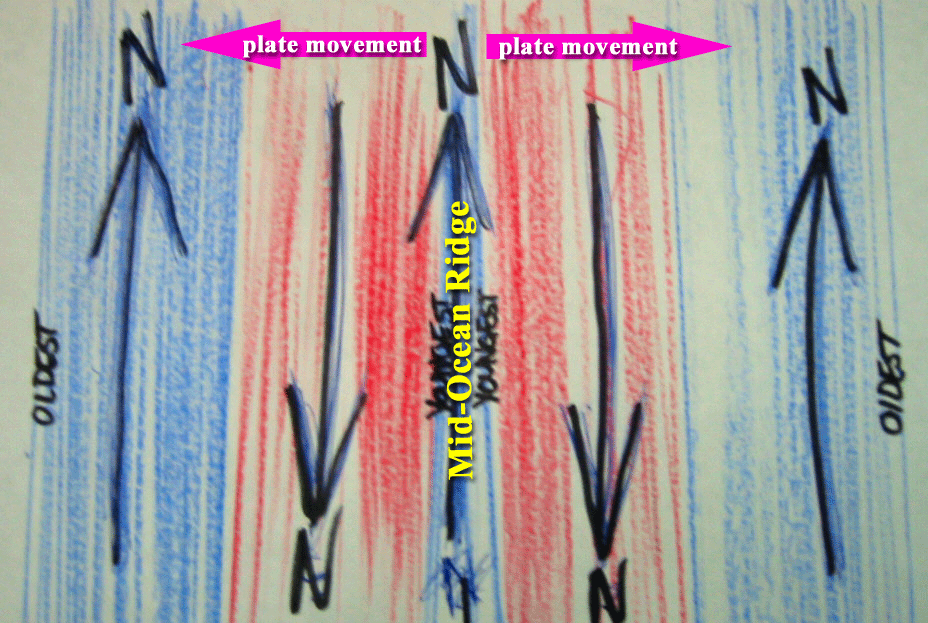 How did they test to see if this movement is true?
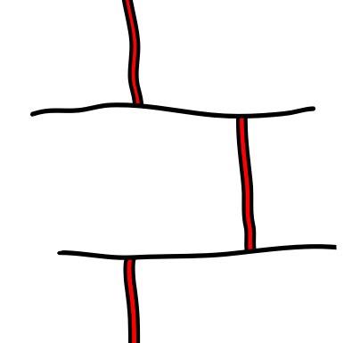
Scientists noticed that the ridge system seemed broken or offset in many places along the mid-ocean ridges.
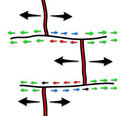
They also figured that if the mid-ocean ridges were spreading apart, then there would be places where the ocean floor would be moving in opposite directions.
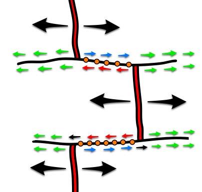
And they hypothesized that there would be more earthquakes in these areas.
And
Low and behold,
That is where the earthquakes occurred!
These broken ridge zones became known as transform faults and this revelation helped us to understand more about how the world works!
Evidence for Sea-floor Spreading
Oceans have giant mountain chains in the middle called mid-ocean ridges.
The crust is hotter near the ridges.
The age of the ocean rocks is younger near the ridges.
The farther from the ridge, the older the oceanic rock.
Transform faults occur where ridges are offset.
Magnetic striping appears along the ridges.
This shows that ocean crust is formed at the ridges and moves away from the ridge, sometimes separating the continents!
Slicing into the Asthenosphere!
Click below for a very good but more technical explanation of Plate Tectonics!
http://www.tulane.edu/~sanelson/eens1110/pltect.htm
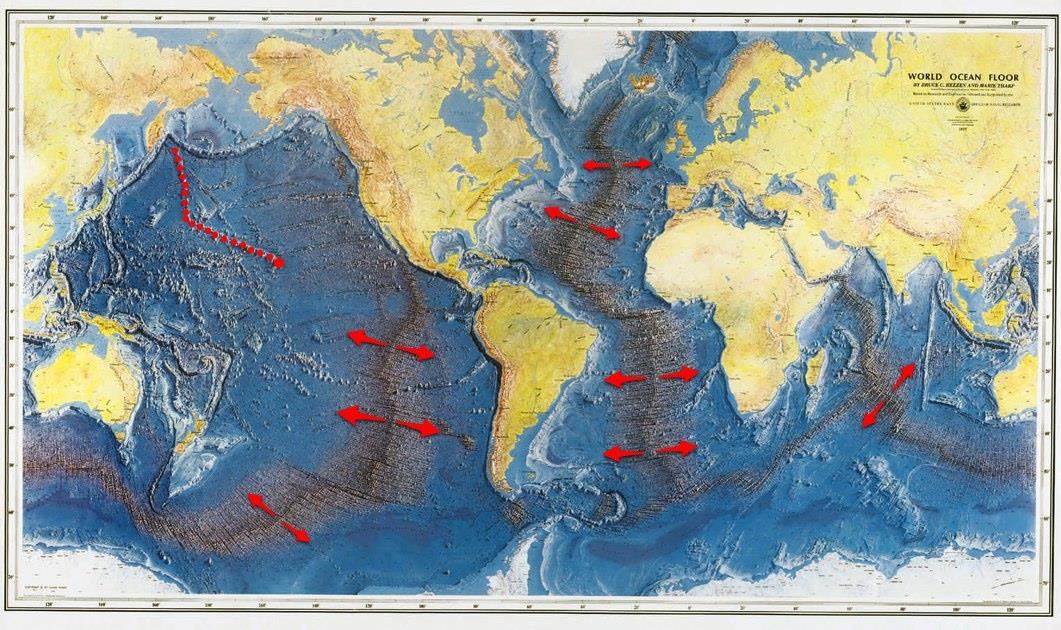
We are going to slice through the earth along line A-B drawing a profile.Divergent Plate Boundary
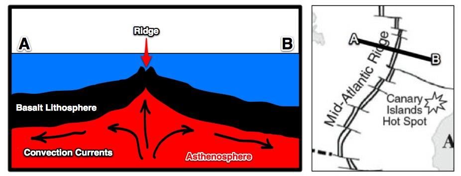 Divergent Boundary -- New oceanic crust is created as the tectonic plates pull apart.
Convection Currents in the Mantle (Asthenosphere) separate the tectonic plates.
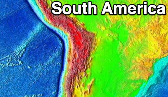
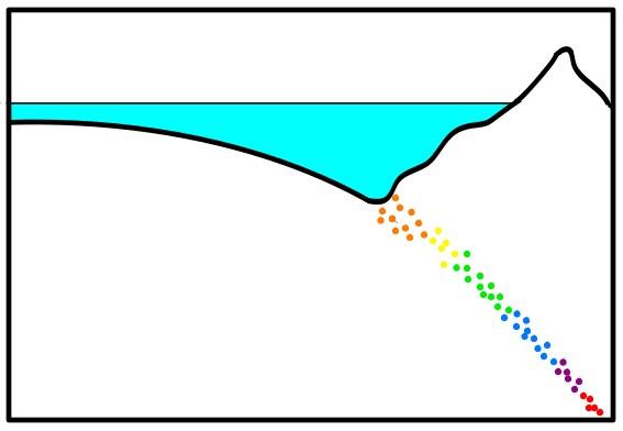
We are going to slice through the earth along line C-D drawing a profile.Convergent Plate Boundary
 Convergent Boundary Profile – Old oceanic crust is destroyed as the tectonic plates collide.
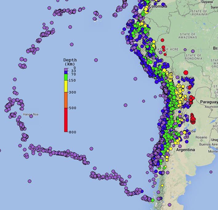
What do the lines of different colored earthquakes suggest?
SUBDUCTION!
Subduction occurs when one plate dives under another, creating a trench and mountain range.
What do the earthquakes show?
Wadati-Benioff zone outlines subducting plates
 Now that you have drawn a few profiles, what would the following profile (E-F) look like?
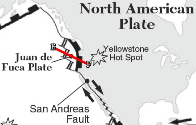
Putting everything together, we should understand that the evidence for the Theory of Plate Tectonics is overwhelming!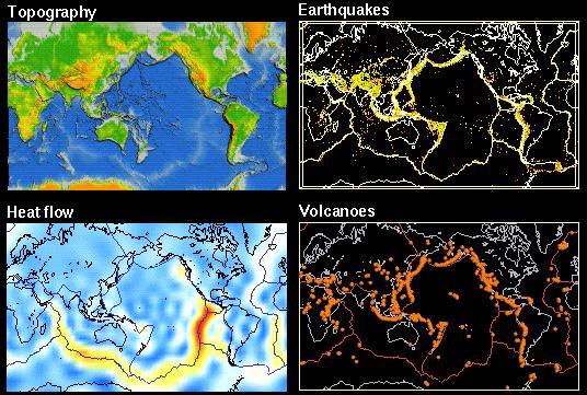 Mountain Ranges form along the edges of Tectonic Plates
Earthquakes happen along plate boundaries
Volcanoes form along plate boundaries
Earth's crust has a higher heat flow at mid-ocean ridgesDefining the Moho!Please take out your reference tables.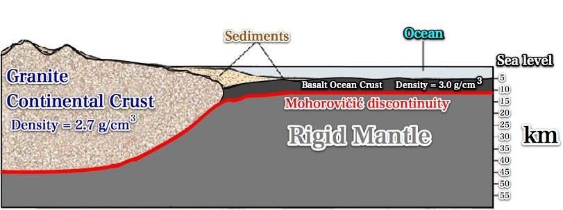
http://geology.com/articles/mohorovicic-discontinuity.shtml
What is the Mohorovičić Discontinuity?
The Mohorovicic Discontinuity, or "Moho", is the boundary between the crust and the rigid mantle. The red line in the drawing below shows its location.
In geology, the word "discontinuity" refers to a surface on which seismic (earthquake) waves change velocity (speed). One of these surfaces exists at an average depth of 8 kilometers beneath the ocean basin and at an average depth of about 32 kilometers beneath the continents. At this discontinuity, earthquake waves accelerate (speed up). This surface is known as the Mohorovicic Discontinuity, or it is often simply referred to as the "Moho."
The continental crust is thicker but less dense than the Oceanic crust.
Can you find the MOHO on your reference tables?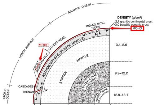 Between what two layers is the MOHO?Crust and the Rigid MantleWhy does the Earth have two levels?Watch the video above to find out!
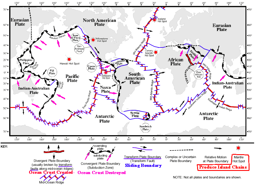
 HawaiiHawaii is a mafic volcanic chain found in the middle of the Pacific Ocean.
It is NOT found at a mid-ocean ridge system.
Hawaii
Hot spot volcanoes often have a chain of volcanoes that leads to the most active volcano. These volcanoes get older and more eroded as you travel along the chain away from the hot spot.
What does this suggest is happening to create these volcanic chains?
The Pacific Plate must be moving over a hot spot in the mantle, creating a chain of volcanic islands that get older as they are pulled away from the hot spot.
http://geology.com/usgs/loihi-seamount/
http://earthobservatory.nasa.gov/IOTD/view.php?id=3510
Something funky about the underwater seamounts along the Hawaiian Island chain
Under the ocean surface, the long chain of submerged islands takes a turn.
What does this suggest?The Pacific Ocean Tectonic Plate must have changed directions.
But we are not very certain why.
http://pubs.usgs.gov/gip/dynamic/Hawaiian.html
How do you think these ringed islands form?

Volcanic Island becomes an Atoll!
Sometimes, Atoll islands are formed as they sink beneath sea level and move away from the hot spot.
Which hot spot volcano is more dangerous, the Hawaiian Volcano of Kilauea or Yellowstone National Park? Why?
http://www.solcomhouse.com/yellowstone.htm
Path of the Yellowstone hotspot
Yellow and orange ovals show volcanic centers where the hotspot produced one or more caldera eruptions- essentially "ancient Yellowstone"- during the time periods indicated. As North America drifted southwest over the hotspot, the volcanism progressed northeast, beginning in northern Nevada and southeast Oregon 16.5 million years ago and reaching Yellowstone National Park 2 million years ago.
Read more about our supervolcano national park at:
http://volcanoes.usgs.gov/yvo/faqs.html
http://www.bbc.co.uk/science/horizon/1999/supervolcanoes.shtml
http://news.bbc.co.uk/hi/english/sci/tech/newsid_628000/628515.stm
http://volcanoes.usgs.gov/yvo/figures/fig2.html
Top 11 things that the Theory of Plate Tectonics explains!Write these in your journal.
1. Shape of the coastlines: They fit together like puzzle pieces
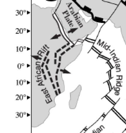
(even better along continental shelves)2. Fossil evidencea. Mesosaurus, Glossopteris, Cynognathus, and Lystrosaurus fossilsb. Many more thousands of fossils not discovered by Wegener3. Rift Valleys of Africa - New ocean forming and volcanoes lined up in Eastern Africa (rift valley)4. Geologic similarities between S. America and Africaa. Same sequence of layered sedimentary rocks
b. Mountain belts, ash deposits, all line-up5. Paleoclimatic evidence (ancient climatic zones match up)a. Layers of glacial deposits are found at the same place in the sequence of rocks *Note: the directions of glacial ice movement as indicated by striations or grooves in the rock
b. Coal is found in very cold climates (coal is formed in tropical environments).6. Young ocean basins and seafloor rocksa. Thin layer of sediment on basalt (thickest near continents)
b. The oldest ocean crust is about 200 million years old, while the oldest continental crust is over 3 billion years old.7. Evidence for subsidence in oceansa. Flat-topped seamounts and ring-shaped islands
b. Deep ocean trenches are located close to the continents.8. Mid-ocean ridges located near ocean centersa. High heat flow
b. Seismic wave velocity decreases due to high temperatures
c. Valley along the center of the ridge with many normal (tensional) faults
d. Volcanoes along the ridge support chemosynthetic life.
e. Earthquakes along the ridge where the plates are offset *Transform Faults9. Benioff Zones - inclined zone of earthquake foci (plural of focus) near deep-sea trenches10. Magnetic stripes on the seafloor capture the magnetic history of the past like a conveyor belt.11. Hot Spot Island Chains - Chains of volcanic islands that get older further away from the site of current volcanic activity.
For example, the Hawaiian Island chain
Today, with satellites and GPS, we can measure the motion of Plate Tectonics.It is an observational fact!http://geology.about.com/od/platetectonicmaps/ss/Map-Of-Global-Plate-Speeds.htm
The Theory of Plate Tectonics explains these tectonic plate observations and the millions of other puzzle clues that help explain how Plate Tectonics works.
Plate Tectonics Theory demystifies all these things that, for centuries, humans did not understand!
ReflectionExplain in a paragraph how plate tectonics work.
Do you feel more comfortable with these concepts in Plate Tectonics?
Why or why not?